
Development Conditions
Kennedy Space Center was developed in the 1960s to support the launch capabilities of the Saturn V rocket in support of the Apollo Program. Prior to this development, this area was largely undeveloped and dominated by low-lying salt marshes and palmetto scrub lands, with limited existing infrastructure and development associated with small agricultural and fishing communities. Modifications to the Merritt Island site by U.S. Army Corps of Engineers were made to support Saturn V launch operations with the ability to be altered to meet the launch requirements of future NASA programs.
Today, approximately 7,500 acres are actively used to support space mission operations, leaving approximately 95 percent of KSC’s 141,829-acre land area largely as it was when acquired and relatively undisturbed from its natural condition. The remaining lands are managed by partner agencies including the United States Fish & Wildlife Service (USFWS) as the Merritt Island National Wildlife Refuge (MINWR) and by the National Park Service (NPS) as the Canaveral National Seashore (CNS).
Natural Environment
The unique relationship between spaceflight and protection of natural resources is carefully orchestrated to ensure that both objectives are achieved with minimal conflict. KSC has enabled undeveloped portions of its land to be managed for wildlife habitat conservation in conjunction with USFWS, while also providing public access for recreational purposes to pristine coastal beaches, inland waterways, and nature trails (as a conditional and non-interfering use).
Wildlife
KSC is home to an abundance of unique wildlife habitats that have been designated as federally significant. The MINWR provides habitat for more than 1,000 plants and more than 500 wildlife species, including 330 bird species, 90 of which nest in the refuge. Likewise, the Indian River Lagoon is a designated “estuary of national significance,” which is home to 400 species of fish, 260 species of mollusks and 479 species of shrimp and crabs.
KSC is home to 15 wildlife species that are currently federally listed as threatened or endangered – more than on any other national wildlife refuge in the continental United States. Habitat associated with the Florida scrub jay, Caribbean manatee, gopher tortoise, and indigo snake are of particular species management concern. Especially important is the Florida scrub jay, whose habitat encompasses approximately 25,954 acres at KSC. This is the only species of bird found exclusively in Florida, thus, KSC and the MINWR actively manage and protect its habitat through prescribed burns and mechanized vegetation work. Any development activities that could potentially destroy habitat associated with these species, or impede the management of habitat through controlled burns, must be carefully evaluated for impacts.
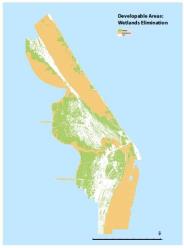
There are 41,425 acres of wetlands consisting of estuarine and marine, lake, freshwater pond, freshwater emergent, freshwater forested/shrub, and riverine land categories. Destruction or impacts to wetland areas, or upland scrub deemed critical to species management or preservation may require significant mitigation and associated additional development costs. Open water constitutes 56,385 acres of land area unsuitable for development, including Mosquito Lagoon, portions of the Indian and Banana Rivers and associated waterways.
Built Environment
In addition to development constraints associated with conservation of the natural environment, the built environment – current, historical and pre-historical – has key characteristics unique to the spaceport that influence development suitability and development capacity. These considerations include Quantity Distance (QD) arcs, lines of sight and vehicle impact limit lines. Principals that have historically guided land use planning at KSC include risk avoidance for the general public, risk management for center personnel and the proactive mitigation of cultural resources. This includes keeping the general public separated from launch hazards by establishing significant safety buffers, as well as limiting access to hazardous areas by KSC personnel as appropriate to the nature of the hazard and corresponding mission requirements.
Line of Sight
Telemetry and other data acquisition require an unimpeded “line of sight” between collection devices and the object being tracked, normally a spaceflight vehicle on the launch pad or in flight. Line-of-sight corridors are managed internally through height restrictions and siting processes in coordination with the CCAFS
Environmental Remediation
Some sites at KSC have been environmentally contaminated by past practices. KSC has an environmental remediation and monitoring program to address these issues. Development in environmental remediation areas should be avoided in favor of unencumbered sites. Environmental baseline studies documenting existing conditions and identification of any past contamination are carried out by NASA prior to allowing any new uses or users to develop or redevelop on KSC property. All land and facility usage agreements with new spaceport users contain language that requires them to accept liability for their future activities.
Quantity Distance Arcs
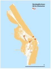
Quantity Distance (QD) arcs and launch/landing hazard impact limit lines are safety zones that are dependent upon the explosive nature of an activity, or the potential for debris and hazardous materials to impact the ground or population in the event of a launch or recovery mishap. QD arcs encompass approximately 1,842 acres at KSC and are concentrated in vertical and horizontal launch, assembly integration and testing, and space systems test and processing areas.
Cultural Resources
In compliance with the National Historic Preservation Act (NHPA) and NPR 8510.1, NASA Cultural Resources Management, KSC has an active Cultural Resources Management Plan (CRMP) that is updated every five years. Consistent with Section 110 of the NHPA, the CRMP encourages a proactive approach by KSC managers in recognizing the cultural and scientific value of the cultural resources that are under their jurisdiction.KSC manages more than 100 historic properties and 185 archaeological sites, some of which are listed in the National Register of Historic Places. KSC also manages 21 resources of the “Cape Canaveral Air Force Station Historic Landmark.” This Master Plan complies with the CRMP and all development that occurs at KSC must consider cultural resources and integrate them into the decision-making process.
Development Suitability
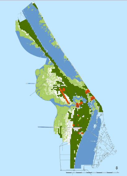
Developable land was identified by removing areas that were considered unsuitable for development including water, wetlands, land within an existing QD arc, critical wildlife habitat, or roads from the 141,829 acres of KSC land. When removing these areas from consideration, a total of 15,294 acres of land is suitable for development without mitigation measures or other restrictions. Approximately half of the developable land area is currently developed; yielding approximately 8,000 acres for future development, which provides a land resource foundation for the future development plan. Development suitability criteria and the resultant land area filtered as unsuitable for development is summarized in KSC’s development suitability map to the left.